Here's an 1857 ad from the Alexandria Gazette, for the land that is now Accotink Village:

Today all that remains of the village is one street, which runs for about two blocks; the rest has been swallowed up by the mammoth Fort Belvoir and the high-volume Route 1 corridor. If you turn onto Backlick Road from Route 1, you'll find what's left of the village. The street boasts some early-20th-century houses and a Methodist church that dates to the late 1800s. But the days are numbered for this quaint little slice of the past; the county has approved the plans to build a mixed apartment/retail complex here (283 multifamily dwellings [read: "apartments"] and 24,825 square feet of "secondary uses"--on land that's currently occupied by just 8 single-family houses). The rest of the street probably won't last long either; the "Statement of Justification" by the developer assures us that "the consolidation and design does not preclude any of the other parcels in the Village of Accotink from redevelopment to their highest and best use." (emphasis added)
Here's a map showing the location of Accotink village. The yellow rectangle shows the entirety of what's left of the village. Note the red oval on the left side of the map. This is more or less the terminus of the old Accotink Road. The train tracks there were part of a spur of the Richmond-Fredericksburg-Potomac Railroad that split off at Long Branch Station and ran to Fort Belvoir (originally Camp A. A. Humphreys). See my blog post Ghost Roads for more about this train route and about Accotink Road.

Because this region was settled in the 1800s, I wonder what artifacts lie beneath the surface in what's left of Accotink village. The 2013 Fairfax County Comprehensive Plan says that "Large portions of the Mount Vernon Planning District have not been surveyed to determine the presence or absence of heritage resources. It is important that these areas be examined before they are developed and appropriate action taken to record, preserve and/or recover the significant resources." I've read almost nothing about this in the plans to repurpose the village of Accotink.
Click on any of the photos to see a larger version.

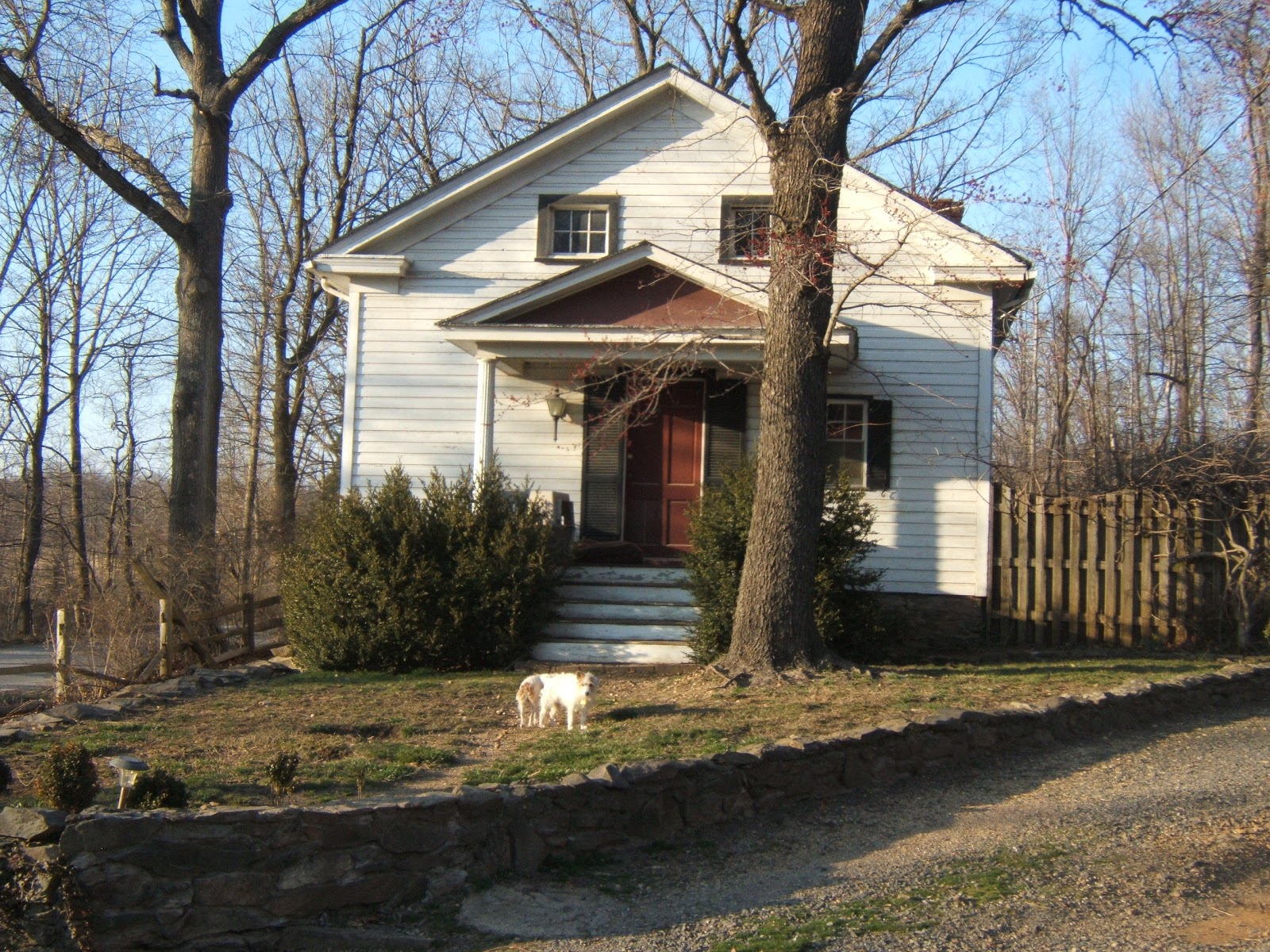
Accotink United Methodist Church, founded 1880. (This church is a local landmark
as identified on the Fairfax County Inventory of Historic Sites.)
as identified on the Fairfax County Inventory of Historic Sites.)

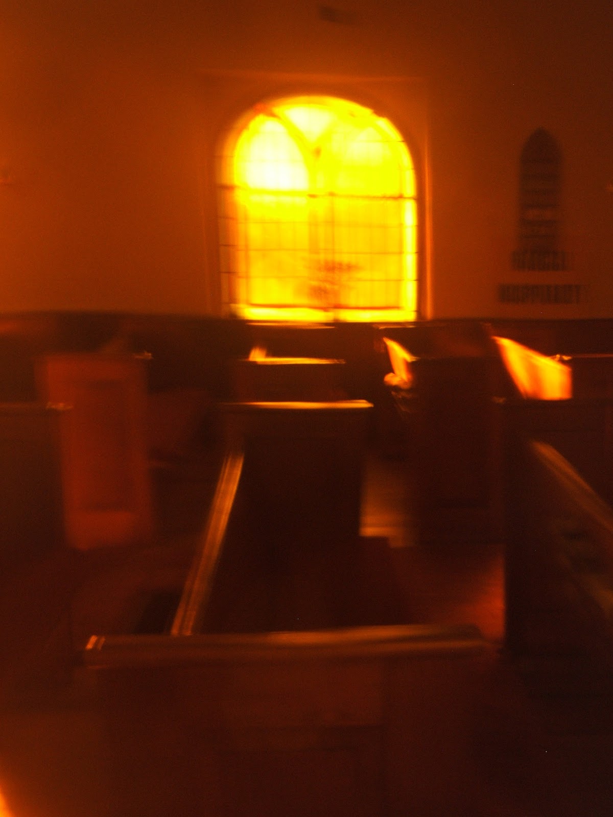
Above and below: interior of the Methodist church. Below, there's an upright piano
in the foreground and a very old pump organ at rear.


Bell tower. The bell used to call children to the school that once stood next door.

Cemetery at Accotink United Methodist. (For a complete list of graves, see http://www.findagrave.com/cgi-bin/fg.cgi?page=gsr&GScid=2182249)

Graves of Jane and John Cawman

Grave of George B. Fairfax, husband of June Fairfax; Fairfax is a
rather famous surname in these parts. Since this church is on property adjacent to Fort Belvoir, and the army purchased the land for the fort from William Fairfax in 1741, I'd wager that this gent was related to that family. (Note the Confederate flag, a common fixture
at cemeteries in this area.)
at cemeteries in this area.)

Does anyone know what this metal plaque represents?

"In loving remembrance of Ralph A. Stout (Oct. 26, 1898 - June 27, 1911):
A beautiful bud taken from Earth to blossom in heaven."
A beautiful bud taken from Earth to blossom in heaven."

And next door to the Methoidst church we have Chua Hoa Nghiem Pagoda:
Buddhist Association of America, a shiny new addition to the block, circa 2009.


9108 Backlick Road: the house is across the street from the Buddhist Pagoda and
appears to be owned by the same organization; this house was built in 1925.
appears to be owned by the same organization; this house was built in 1925.

9121 Backlick Road: the oldest house on the street. It was built in 1900. In the 2011 Fairfax County Comprehensive Plan, they recommended that this house be documented and evaluated for inclusion in the Fairfax Co. Inventory of Historic Sites. It's was foreclosure and was for sale for $239,000. (See http://tinyurl.com/m6nnz53.) UPDATE: It's no longer for sale, and it has new siding; you wouldn't recognize it.

Words fail me.

Ditto.

The same house, from the street view of Google Earth, before it fell on hard times
(it's now boarded up and the bay window is broken).


This 1903 house is a time capsule; beneath the white siding, there is brick, stone, and wood,
evidence of various owners' efforts to remodel.
evidence of various owners' efforts to remodel.
 |
Magnus Masonic Lodge, built in 1925. It's at 9012 Backlick Road. The county is looking into the possibility of granting historic status to this structure. The lodge is home to a local chapter of the Ancient Egyptian Arabic Order Nobles Mystic Shrine of North and South America and Its Jurisdictions, Inc. (more commonly known as "Shriners). The Ancient Egyptian Arabic Order is a historically black order of the Shriners, organized in Boston in 1784.

Maybe if you have to ask, you don't need to know.

Reserved parking for the Elected Imperial Officer

Parking reserved for the Illustrious Potentate

Looking toward the end of the road, which dead-ends at the border of Fort Belvoir
and curves to the left to take you to the Fairfax County Parkway.
and curves to the left to take you to the Fairfax County Parkway.

Looking toward Route 1

The end of the road: Backlick dead-ends here. The overpass was used as part of a spur that went from the Long Branch station to Fort Belvoir, a story in itself.
Beyond the overpass is a gate to Fort Belvoir; the road used to continue on to Beulah St. here.
Beyond the overpass is a gate to Fort Belvoir; the road used to continue on to Beulah St. here.

The original grist mill, on a survey map made in 1859:
And a look back at the village in 1862:

And the village in its heyday (circa 1900):

The proposed mixed-use development that's going to swallow up a corner of Accotink Village:

The tiny, remaining slice of Accotink Village is virtually surrounded by Fort Belvoir (in fact, its mailing address is Fort Belvoir, Virginia). The families who live on this street have no other neighbors. The children have no one to play with, no nearby parks. This kind of situation is ripe for demolition and replacement by a subdivision or commercial development. I've seen it before--well-kept, tidy homes and mature trees are bulldozed, and residents are displaced. Land in Fairfax County is very dear, and I acknowledge the need to maximize the available space. But there are only so many houses left from the turn of the twentieth century. When all the old houses are gone, it's going to be a long time until there are old houses again. Today, if you blink, you'll miss the village of Accotink. Soon, even if you keep your eyes peeled, it won't be there to see.
Sources:
- 2011 Fairfax County Comprehensive Plan: http://www.fairfaxcounty.gov/dpz/comprehensiveplan/adoptedtext/2011-04.pdf
- Zillow.com: http://www.zillow.com/homedetails/9121-Backlick-Rd-Fort-Belvoir-VA-22060/51989590_zpid/
- Northern Virginia History group on Facebook (https://www.facebook.com/groups/199423696893155/)
- South County Federation Land Use Committee: http://tinyurl.com/nr9oe8r
- Mills and Mill Sites in Fairfax County, Virginia, and Washington, DC: http://tinyurl.com/nudbxda
- Belvoir in the Antebellum Period: https://www.belvoir.army.mil/history/Antebellum.asp
- Ancient Egyptian Arabic Order Nobles Mystic Shrine of North and South American and Its Jursdictions: http://www.aeaonms.org/
- ANCIENT EGYPTIAN ARABIC ORDER OF NOBLES OF THE MYSTIC SHRINE et al. v. MICHAUX et al.: http://www.law.cornell.edu/supremecourt/text/279/737
- "Narrative Statement of Justification for Village of Accotink Mixed-Use Project": http://www.mvcca.org/pz/2012-09_Accotink-SOJ.pdf
- Belvoir Enters the Twentieth Century: https://www.belvoir.army.mil/history/20C.asp
- Realtor's blog: http://activerain.com/blogsview/3378032/village-of-accotink-if-you-blink-you-will-miss-a-piece-of-fairfax-county-history
- Find a Grave: http://www.findagrave.com/cgi-bin/fg.cgi?page=cr&CRid=2182249
Copyright 2013. All rights reserved.


